Building Data Collections for Better Decisions on the Farm
Researchers are building sets of geography and mapping data (also called geospatial data) from multiple sources to give farmers the distinct advantage of seeing where, how, and when conditions and crops are changing. This enables them to adapt to these different variables, monitor the health of individual crops, estimate yields from a given field, and maximize crop production. This effort is being supported by the NSF-funded Internet of Things for Precision Agriculture (IoT4Ag) Engineering Research Center (ERC) headquartered at the University of Pennsylvania.
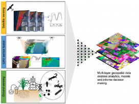
IoT4Ag's research goals include creating low-cost, low-to-no-power sensors that provide data for a hybrid biophysical model-based and data-driven farm operations decision control system for timely and optimized responses across each stage of the crop lifecycle. Multi-layer, multi-source geographic data will help overcome current limitations. While much of the sensor data collected on farms has geospatial information embedded, satellites collect imagery at high frequency and across large scales, but often at coarse spatial resolution. Unmanned aerial vehicle (UAV)-mounted sensors provide high spatial resolution with ondemand flights but with limited data quality and cannot see through the plant canopy. Sensors mounted on trees, in the soil, and on groundbased robots can measure variables we cannot "see" with satellites and UAVs. When fused together, these data will provide a view of the farm that no one sensor technology can do on its own, and the data can be translated into actionable information for food production. IoT4Ag researchers are collaborating across campuses, states, and testbeds, to build a dataset that will be representative of the situations growers face across the nation and the world. This data set will then enable the development of new AI fusion techniques that can work across varying scales, time, and spatial resolution.
The growth and yield of crops are highly dependent on the physical and chemical properties of the soil and microclimate where plants are grown. These include stress conditions such as drought and nutrient deficiencies and biotic stresses related to pests and diseases. However, the inception of stress events is usually highly variable, both spatially and temporally. For example, critical soil properties like plant available water usually vary substantially by soil depth and texture, within a field, and within a growing season. This leads to highly variable crop responses that are integrated at a field scale in the form of impacts on yield and quality once the crop is harvested.
Geospatial data is data about objects, events, or phenomena that have a location on the surface of the earth. The location may be static in the short term (e.g., the location of a road, an earthquake event, children living in poverty) or dynamic (e.g., a moving vehicle or pedestrian, the spread of an infectious disease). The data in agriculture involves a wide range of spatial/time scales and modalities and may involve complex spatial analyses to compare variables like soil type, wind direction, rainfall amount, slope, aspect, topography, or elevation to assist with crop management, site suitability, and drainage planning, as well as risk prevention from flood, drought, erosion, and disease. The basic collection of data is an important first step to advancing data science techniques that fuse measurements from multiple sources together. Among the most powerful and commonly used tools in a geographic information system is the overlay of cartographic information. An overlay is the process of taking two or more different thematic maps of the same area and placing them on top of one another to form a new map.


